By Eric Jensen
Whether at our Southern border, in the South China Sea, or on the fields of eastern Ukraine, the need for rapid, reliable intelligence is indispensable in the age of democratized lethality.
Advancements in attritable technologies are redefining adversarial capabilities, and yet outdated acquisition strategies continue to mire our preparedness. This is especially true for the domain of Geospatial Intelligence, a discipline that relies on multiple data sources including imagery, signals, and geographical information to create insights about activities on Earth.
In recent years Congress has asserted that to maintain our defensive edge, the government must lean more heavily on the commercial intelligence, surveillance and reconnaissance (ISR) industry to reinforce military leaders’ understanding of threat developments around the globe.
The incoming Congress should capitalize on the demonstrated advantages of the commercial remote sensing industry for our nation’s defense architecture.
Fueled by billions in invested capital, advances in microelectronics, and affordable access to space, hundreds of earth observation satellites have been deployed in the past five years — a historic pace.
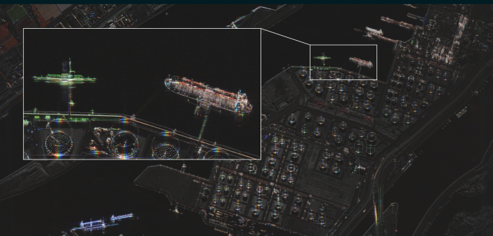
Taken together, electro-optical, radio frequency, and Synthetic Aperture Radar (SAR) collectors in orbit today provide information from any global location, land or sea, multiple times per hour. With half the Earth perpetually shrouded in its own shadow and 70 percent of sunlit area under constant cloud cover, SAR imaging sensors have proven their ability to extend our forces’ reach in regions where our adversaries are increasingly assertive.
To harness these ISR capabilities, the United States must take the lead in establishing and funding multi-year programs to integrate high-quality commercial data streams that rapidly benefit the joint force in three key areas.
Information from commercial radar imaging systems is timely, accurate, and increasingly critical to the government for assessing economic and military threats.
“China is not a future threat; China is a threat today,” said Air Force Secretary Frank Kendall in September. China shows little interest in slowing its aggressive military fortification campaign in the South Pacific. From infrastructure development on disputed islands, to mobile weapons caches, to natural resource capture, space-based ISR technologies allow for tracking activities and exercises that otherwise go unnoticed.
Nevertheless, thousands of daily monitoring requests will continue to be unserved without the last mile effort to ensure military intelligence analysts have training and access to the latest offerings from the commercial remote sensing market. Integrating commercial partners alleviates the strain on national systems and produces better, faster outcomes for the U.S. and our allies.
Second, enhancing maritime domain awareness is essential to our stability as the U.S. and our allies face evolving threats in global waterways. Cargo vessels annually carry more tonnage and value in U.S. traded goods than any other mode of transportation.
Monitoring capabilities from commercial SARcompanies are a natural fit for maritime security. These technologies are today being used to characterize and track piracy in the Red Sea, intercept illicit ship-to-ship transfers, and identify illegal fishing activity.
Coalescing the data from SAR constellations within government systems provides access to continuous surveillance capabilities regardless of weather or time of day, enabling the U.S. to safeguard economic and security interests around the world.
Finally, commercial remote sensing capabilities provide invaluable utility closer to home, from natural disaster response to border security. In the aftermath of the Lahaina Fire and Hurricanes Helene and Milton, commercial radar was used, for example, to identify landing zones for hundreds of helicopters in concert with federal, state, and local authorities.
Related efforts leveraged commercial radar sources to assess real-time damage, guiding rescue crews on life saving missions and expediting infrastructure recovery. Radar imaging systems are gaining traction as resources in the fight against drug and human trafficking at our borders as they offer an unincumbered source of truth for migration patterns and illegal operations.
The incoming Congress has an opportunity to accelerate the adoption of commercial space-based ISR solutions by prioritizing policies and funding that result in their operational integration into our defense ecosystem. Capacity from commercial earth observation constellations is vital to complement the decade-long development cycles of other government investments in ISR.
Defense and intelligence organizations must fast-track the establishment of formal pathways to ensure cutting-edge commercial ISR capabilities are readily accessible to the warfighter with the speed required to maintain the upper hand.
Now is the time for Congress to align on a strategic vision that harnesses the full potential of commercial space-based ISR to safeguard our nation and maintain the stability required for economic flourishing.
Eric Jensen is the CEO of ICEYE US.


